

Atlantic City, Brigantine anchorage
For cruisers traveling the Atlantic coast of New Jersey, there are two very different routes from which to choose, or from which one can mix-‘n-match as weather conditions vacillate. Between Cape May and New York Harbor, cruisers can either travel offshore in the coastal Atlantic Ocean or take an “alternate” ICW route that runs the shallow bays and rivers lying inside the coastal barrier islands of the New Jersey coast. I have posted a separate article on transiting the Delaware Bay between the C&D Canal and Cape May. That article is located here: https://gilwellbear.wordpress.com/category/cruising-practica/us-east-coast/delaware-bay/.
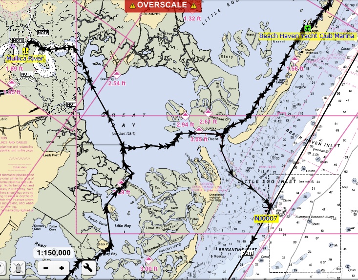
Little Egg Inlet, Great Bay, Mullica River anchorage
Weather and sea state permitting, the offshore route around New Jersey is shorter, less complicated and less demanding. Most of the offshore run can be done within a mile or so of shore, and it’s never necessary to be more than 3 miles offshore in 40 – 60 feet of water. Most of the major inlets are marked with safe water pillars, and these pillars make useful reference locations for cruisers to use in route planning. There are major inlets protected by large jetties at Cape May, Atlantic City, Barnegat Inlet on Long Beach Island, and Manasquan Inlet. Little Egg Harbor is also navigable by cruising boats. The New Jersey inlets are geographically small and carry very large volumes of water into and out of large inland embayments. Maximum flood and ebb currents in the inlets are very swift. Inlets also carry lots of small-boat traffic. Beginners in low-powered, slow boats are advised to avoid transiting Barnegat Inlet and the lesser inlets in the hours of max flood and ebb. Navigation conditions at all New Jersey inlets can be treacherous when significant winds and tide-driven sea states oppose, so forethought and caution are paramount and local knowledge through contact with Tow BoatUS or SeaTow is advised.

Barnegat Inlet, Barnegat Light, Myers Cove anchorage
The New Jersey ICW extends from Cape May in the south to Manasquan Inlet in the north. The State of New Jersey never completed the ICW segment between Manasquan and Atlantic Highlands, so there is no inside passage from Manasquan to the Shrewsbury River and on into Raritan Bay. Cruising boats must transit 40 StM offshore from Manasquan to the Verrazzano Narrows Bridge (the “Narrows”) at NY Harbor. Sea conditions in Raritan Bay and off the New Jersey coast are variable. Swells of 4′ and winds less that 15 kts are very comfortable. These waters can become uncomfortable in winds greater than 20 kts. Distant deep-water ocean storms that can create larger swells. All ocean swells become larger in height and shorter in period as they approach the coastal shallows. Some nearshore shoaling does occur. Seas will be abeam in all winds with an East component, and beam seas usually make for a rollie-pollie ride. In a “normal” season, there are frequent periods of calm weather in this region. Avoid going offshore during and immediately after periods of easterly winds of 20 kts or more. When easterlies are blowing offshore, water depths inside are slightly improved, making travel inside somewhat easier. In westerly winds, we run offshore, within 1/2 mile of the shoreline for calm seas. Avoid the inside in westerlies, because water depths inside will be lessened. If sea states have been “up” for several days, allow at least 24 – 36 hours for seas to settle down before departing. Do not venture offshore if thunderstorms are forecast, because places to get back inside are relatively far apart, and storms offshore can be treacherous.
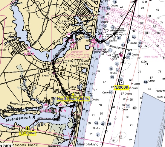
Manasquan Inlet, Point Pleasant Canal, Metedeconk River anchorage
The NJ ICW is marked as an Intracoastal Waterway, with red markers inland and green markers seaward. Where inlet channels cross the ICW, marker colors can and do reverse sides. Extremely careful attention in this route is required at all times! The general guideline is to follow the outside radius of curves, but in all cases, honor markers in the water. CRUISER’S ARE ADVISED NOT TO TRUST THE POSITION OF THE “MAGENTA LINE” ON OFFICIAL NOAA CHARTS. THEY ARE – AT BEST – A GENERAL GUIDE. DILIGENT ADHERENCE TO THE PATH OF THE MAGENTA LINE WILL TAKE THE BOAT AGROUND. NJ ICW CHANNEL LOCATION CHANGES VERY FREQUENTLY IN MANY PLACES. THE NOAA CHARTS ARE ALWAYS OBSOLETE IN SOME LOCATIONS. ALWAYS, ALWAYS HONOR THE MARKERS IN THE WATER.

Absecon Lighthouse, Atlantic City, NJ
The New Jersey ICW is either 1) shallow, narrow and serpentine, or 2) very shallow, very narrow and very serpentine, or 3) extremely shallow, extremely narrow and extremely serpentine. The mostly salt marsh segment between Cape May and Atlantic City is the most tedious. At high tide, this waterway appears wide, but the navigation channel itself is very narrow. Channel edges are clearly visible at low tide. The southern segment is further complicated by the presence of several draw bridges that most cruising boats will need opened. These bridges carry seasonally-restricted hours of operation.
All NJ ICW inlet crossings can present uncomfortable sea conditions when the wind is blowing 20 StM/Hr or better from any direction with an Easterly component (NE, E, SE). The ICW segment between Atlantic City to Barnegat Bay is less tedious than between Cape May and AC, but it nevertheless demands the helmsman’s full attention. Barnegat Bay is a large body of water with a very modest tidal range of 6″. The bay averages 6′ water depths throughout. There is a marked ICW channel that through-cruiser’s should follow, but cruisers will see many boats moving about at speed all over the bay.
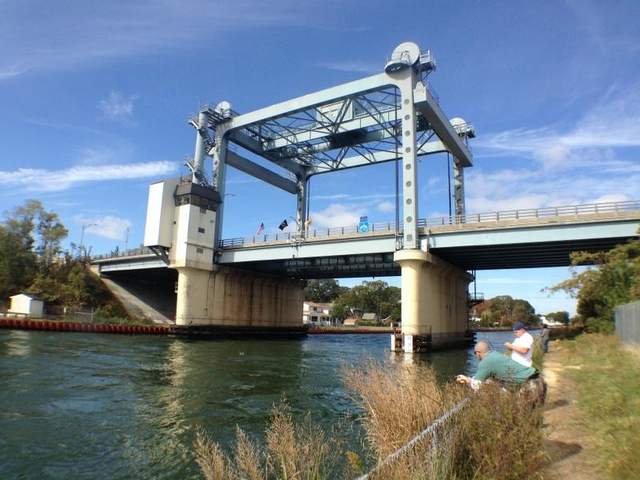
Lovelandtown Bridge, Rt. 33, Point Pleasant Canal, NJ
At the north end of Barnegat Bay is the Point Pleasant Canal. At maximum ebb and flood, the canal carries a very swift current of 4 – 5 kts. Cruisers are advised to avoid it these times. It is narrow and there is a draw bridge. Monk’s won’t need the bridge to open, but it does have a pair of impressive abutments. THE NEW JERSEY ICW DEMANDS YOUR ABSOLUTE AND UNWAVERING ATTENTION. NO LAPSE OF ATTENTION BY THE HELMSMAN IS ACCEPTABLE.
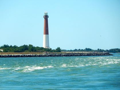
Barnegat Lighthouse from Barnegat Inlet; the turbulence in the foreground is caused by tidal current flow running at maximum ebb.
The ocean inlets along the New Jersey Coast can all present navigational challenges, and can be very tricky. They all carry very swift maximum ebb and flood currents. When entering inlets from the ocean, be especially careful on an incoming tide if there is an easterly wind above 15 StM/Hr. In that case, ocean swells will be breaking in the inlet, but boats approaching from seaward can’t see that until it too late to safely turn around. In these conditions, you risk broaching (or, “getting pooped”). Stay away from areas where breakers occur. Breakers always occur where the water shallows up. Where the inlets intersect the ICW, there are often strong cross-currents that can easily sweep the unwary cruiser sideways out of the ICW channel. “‘BE PREPARED!’ is the Boy Scouts marching song…”

Retired Coast Guard Station, NJ ICW
Prior to Hurricane Sandy, the standard advice for most cruising boats was to transit the NJ ICW at mid-tide or higher, which means, in practice, that parts of the month with high tide at mid-day will be OK, but other parts of the month with low tide at mid-day will be marginal at best. As we all know, Hurricane Sandy destroyed a very great deal of property and facilities in this region. Long Beach Island – formerly about 25 miles long – was over-topped, and is now three separate islands. One of the lowest cost fuel stops on the US east coast was the Beach Haven Yacht Club Marina, which was destroyed by Hurricane Sandy. Fortunately, it has since been rebuilt. On Staten Island, NY, all of the wonderful facilities in Great Kills Harbor were destroyed. For the 2014 season, most have been rebuilt, and Great Kills Yacht Club is back online. Sandy dumped many tons of debris in the NJ ICW channels, and its unlikely they were affected for the better. The State of New Jersey commissioned cleanup operations which took place throughout 2013. Cruisers planning to transit the NJ ICW should contact Tow BoatUS or SeaTow, and ask for detailed, local knowledge BEFORE starting out.
Finally, and unfortunately, New Jersey boaters are among the least courteous boaters on the US East Coast. The locals compete with North Carolina and Florida sport fish captains for the title. Expect to be waked at full speed by 60+ foot sport fish and go-fast boats. Sailboats cannot transit the New Jersey ICW because of several 36′ fixed bridges. Trawlers will be the slowest boats on New Jersey waterways.
All things considered, Sanctuary and crew prefer to transit New Jersey offshore. We try to plan our northbound transits of New Jersey by anchoring overnight in Cape May, nearby the Coast Guard station. Then on the morning of the first day, we take an easy offshore ride to either Atlantic City, where we enter the inlet and anchor in the Brigantine anchorage, or to Barnegat Light, where we enter the inlet and anchor in Meyers Cove. The morning of day two, we plan a longer offshore run to either Atlantic Highlands, NJ, or behind Sandy Hook, NJ, (settled conditions only) or all the way to Liberty Landing State Park, Jersey City, NJ, where we anchor behind the Statue of Liberty, at Liberty Landing State Park (LLSP), in NY Harbor. If sea conditions deteriorate, we can duck out at the Manasquan Inlet and anchor there for the night. We have run inside on the NJ ICW at least three times. We like the trip, but it does come with some anxiety, and it definitely requires diligent and undivided attention.
Qualitatively, the New Jersey ICW is quite interesting, and much more visually appealing than the industrial reputation of New Jersey would allow one to imagine. In the south, this route is quite rural. Mid-state, the route is densely populated with beach house and condo communities. It is unique and different from other east coast cruising locations. It offers a delightful mix of salt marsh, beach communities and open bays. Despite the challenges, we recommend it. Once!

Great article! However I need clarity on a few points:
You said that cruising the coast of NJ north on the ICW “Most of the offshore run can be done within a mile or so of shore, and it’s never necessary to be more than 3 miles offshore in 40 – 60 feet of water.”
I’ve looked at the chart and didn’t see any hazards to small vessels until Sandy Hook. Can you specify?
This last except really confuses me.:
“The State of New Jersey has allowed the ICW segment between Manasquan and Atlantic Highlands to completely shoal in, so it is impassable by cruising boats. This means that from Manasquan to the Verrazzano Narrows Bridge (the “Narrows”) at NY Harbor, cruising boats must transit 40 StM offshore.”
Are you saying boats must stay forty nautical miles off shore?!
I appreciate any clarification
Tony
Hi Tony,
To your first question, along the Atlantic shelf, there are many areas where shoals extend several miles offshore, and where one must run well offshore to avoid them (Charleston, Sapelo Sound, Doboy Sound). That is not the case along the New Jersey coast. The geography of the shelf along NJ is very consistent, and except in the vicinity of the inlets, cruisers can run quite near shore. The inlets change often, particularly Little Egg and Great Egg. Get local knowledge if you plan to use the lesser inlets. So the point is, if you prefer long, straight rhumb lines on autopilot, the straightest lines will take you gradually out to 3 miles offshore from inlet to inlet. But if the wind is up with a westerly component, you can run quite near shore to minimize fetch and get better sea conditions. Because coastal shoaling is more extensive, that strategy does not work well along the Carolina and Georgia coasts.
To your second question, the distance from Manasquan Inlet to NY Harbor is 40 miles (+/-) round numbers. There is no practical “inside” Intracoastal option, so cruisers must transit that stretch “outside,” in the ocean. Northbound, cruisers can run near shore – as described above – until clear of Sandy Hook, then turn to a NNW rhumb line across the mouth of Raritan Bay to the Varazzano Narrows. That total route is 40 miles (+/-) long; it does not take you 40 miles offshore. Stay alert as there is a very active sport fishing area off Sandy Hook. West winds have a significant fetch along the length of Raritan Bay. Between Sandy Hook and the Narrows, west winds are predominantly abeam, and can produce an uncomfortable ride depending on the stability of the boat.
I hope this helps.
Thank you so much for clearing up my confusion.
I’m headed out tomorrow for a 3-day. Brooklyn to Manasquan, get a slip. Next to Barnegat, another slip. The next day all the way back to Brooklyn. My greates concern is Ambrose Channel and NYC channels before the Narrows.
And I’m sorry I haven’t said before; I’ve checked your site several times over the years – it’s wonderful keep it up!!! Check out my site http://www.CaptSqns.com
Thanks!
I’m concerned about them because it will be dark.
Tony,
If you’re asking for my opinion, I WOULD NOT do any of these inlets in the dark. Especially without significant daylight experience. Ebb and flood currents are very strong. You may not be able to assess sea state conditions. And, I honestly don’t know if you can count on all of the markers to be lighted. I would not do it!
I’m also concerned about the ICW, There’s a lot of spots that are 4 feet!!
Your good advice is heard by the choir – I’m not transiting any inlet at dark except for NY. You’re including the mouth of NY harbor in that warning? Now that I consider your specific warnings it’s giving me pause.
We had a great trip and took your advice. We made new friends at an anchorage, then later learned that they went aground ant Sandy Hook Pt. Then we listened on the radio as they abandoned ship. Inlets are no joke.
Thanks for this information.
I will be doing my first ‘outside’ next week, and this helps a lot.
gilwellbear I just came across your site, it is very informative, I was trying to find my way from the great bay to a.c. for a little joy ride with the misses, your maps are really great, I thank you, and hope you ‘ll be keeping the info coming, maps and info can be a little to tricky to desipher sometimes yours are good thanx mikey
I have been wanting to make a comment on this section for awhile. First I also appreciate the “GilWillBear’ site and used it as a mini bible for sections that I needed clarity on. I caught out “GIllWilBear’ when I was winded in at Cape May, and wanted to get going after a 4 day blow.
I did read the famous words:…………..
THE NEW JERSEY ICW DEMANDS YOUR ABSOLUTE AND UNWAVERING ATTENTION. NO LAPSE OF ATTENTION BY THE HELMSMAN IS ACCEPTABLE.
This is so true. But I want to add another concern in the decision to take the NJICW.
IF, after blowing for a period of days, the NJICW is even more demanding on the captains attention. I ran aground in 35MPH winds, due to crab pots being blown into the navigational portion, complicating my ATTENTION to all things required to make the passage. As I slowed down to slalom through the crab pots, the wind blew me off course and into the shallows.
My advice is to NOT take the NJICW section if the winds have blown for days. Wait a day or two and go outside, or when the waters return to the inside, and, go slow with …….
ABSOLUTE AND UNWAVERING ATTENTION. NO LAPSE OF ATTENTION BY THE HELMSMAN IS ACCEPTABLE.
Mark, glad you find the site useful. I definitely agree that high winds can have a negative effect on navigation depths, and certainly that is true in the very shallow NJ intracoastal bays. Take a look at our weather criteria, item 2, listed here: https://gilwellbear.wordpress.com/category/boat-operations/day-of-travel-procedures/. For us, winds at 35 StM/hr would be unacceptable, particular in such confined, narrow, shallow channels. We would almost certainly have stayed put in those conditions.
Yes I was in a Grand Banks 36 Trawler
Hi gilwelllbear,
Thanks for this detailed article. I’m about to make this trip to bring a sailboat I just purchased on the Chesapeake home to Raritan Bay. The info is priceless. — We will plan on doing the entire trip outside for the NJ segment and heed your cautions on inlets! I have an Island Packet 35, draws 4.5′, 19000 lbs.
Can you advise on precautions and concerns for the Cape May channel to/from Delaware Bay? I get conflicting info on current conditions , especially for depths. How/when should I approach this and when to avoid would be appreciated.
Thanks,
Art
I’ve written about the Delaware Bay on this website, here: https://gilwellbear.wordpress.com/category/cruising-practica/us-east-coast/delaware-bay/. The principle concern in this area is weather: wind direction, wind speed and direction of tidal currents. The channel through Cape May Harbor was “dredged” a couple of years ago. It is somewhat shallow, but so is everything in the region; no worse, maybe slightly better, than surrounding waters. Honor the markers, proceed carefully, and you’ll be fine. There is a very large ferry terminal at the Bay entrance to the canal. Watch for these large and fast-moving ferries. Favor the ferry side of the channel (west side), as the prop wash from the ferries causes the far side to be quite shoal.
Where is the retired station, picture in your article, located?
From memory:
39°30.523’N
074°19.446’W
South of Long Beach Island, adjacent to Little Egg Inlet. The chart says “SHOOTING THOROUGHFARE” and calls the area “MARSHLAND ISLANDS.” The raster charts mark it as a “CUPOLA.”